Thursday, February 29, 2024

Santiago de Chile


Just as in Buenos Aires, we used several walks from GPSmyCity to organize our tours of Santiago neighborhoods.  Uber is simple and cheap here, preferable to taxis.  Unlike Buenos Aires, it seemed that every restaurant, no matter how small or casual, accepted credit cards and allowed service to be included in the charge.

We started our visit to Santiago by climbing Santa Lucia Hill to Castillo Hidalgo (fort), then descending to the iconic Neptune Fountain.  The Santa Lucia Market across Avenida Liberador Bernardo O’Higgins is worth a visit.  Farther along Av O’Higgins we turn onto the pedestrian-only Ahumada shopping street.  Plaza de La Constitucion is surrounded by government buildings and contains statues of former presidents.  On the south side of the plaza is the La Moneda (Presidential) Palace, site of the “suicide” of President Salvador Allende during the 1973 military coup that brought Augusto Pinochet to power (more on that later).  The Changing of the Guard (every other day at 10am) was impressive and entertaining.  When the band started playing Michael Jackson’s Thriller, then YMCA, it really broke up the solemnity of the event.  The National Congress moved from Constitution Square to the city of Valparaiso in 1990 as part of the changes brought by the new democratically elected government, intending to decentralize governmental institutions.  

Andes is the distance

Neptune Fountain

La Moneda Palace


Plaza de Armas is a beautiful public square with impressive buildings on all sides, and eateries around the periphery.  First established in 1541, we learned that the Spanish created these “Arms Square” in all their colonial cities as a place of refuge and protection if the city is attacked. On the west side is the impressive Catedral Metropolitana, built between 1748 and 1800.  There have been churches on this site since the mid-sixteenth century (all destroyed by fire or earthquake).    

Plaza de Armas

Metropolitan Cathedral

Cathedral Nave

Churches: in additional to the main cathedral, we visited several impressive churches.  San Francisco, the oldest church in Santiago.  Church of our Lady of Grace has a famous wooden statue of Jesus whose crown of thorns slipped down around his neck during the 1647 earthquake.  Santo Domingo church is beautiful in its simple and austere interior.  Basilica de la Merced possesses a relic reputed to be a sliver of Jesus’s cross, making the Basilica a major pilgrimage site.  

San Francisco

San Francisco

St Michael

Our Lady of Grace

Crown of Thorns


Santo Domingo Nave

Santo Domingo


Basilica Merced

Basilica Merced

Cross relic

The Mercado Central (Central Market) is an impressive structure built in England, transported and reassembled in Santiago in 1872.  It’s home to an eclectic collection of food stalls, artisan shops and eateries.  

Paris-Londres (London) is a small enclave of architectural gems adjoining San Francisco church.  These are among the oldest streets in Santiago, dating to the sixteenth century.  The mansions built along these streets were built in the early twentieth century and resemble the Latin quarter of Paris.  38 Londres was a torture center during the Pinochet regime, and is now a memorial to the victims.  

Paris Street

London Street

London Street


The Lastarria neighborhood is situated between Santa Lucia Hill and Parque Forestal.  It has quaint winding streets, and lots of bars and restaurants, especially along Merced Street.  We had a great dinner at Bar Liguria Lastarria, which has great atmosphere as well.   

We explored the Recoleta neighborhood centered on Avenida Recoleta.  The Church and Convent of the Franciscan Recoleta was worth visiting.  La Vega market near the church provided interesting insight into the local community, as it primarily focuses on meat, produce and household goods.  The Passeo Patronato is a famous shopping street, but we found it to be grungy and underwhelming.  Walking along Santa Filomina leads into Bellavista, which is a very cute neighborhood.  From Castillo Lehuede (Red House) and Plaza Camilo at the base of Cerro San Cristobal (hill), we walked along Pio Nono and Constitucion streets lined with restaurants and shops.  The Patio Bellavista is a huge complex of restaurants and shops.  

Franciscan Recoleta

Castillo Lehuede

Patio Bellavista


Guanaco (llama) crudo

We had a great dining experience at Peumayen in Bellavista.  They specialize in the cuisine of indigenous people from the various regions of Chile.  


It is a short Uber ride to the Museo de la Memoria y los Derechos Humanos (Museum of Memory and Human Rights).  This museum tells the story of the 1973 military coup that ended the Allende democratically-elected government and replaced it with a military junta led by Augusto Pinochet.  It also highlights the personal tragedies of thousands who disappeared.  It is an incredible museum, but is best experienced through the English-language tour.  


Castro and Puerto Montt


Castro (Chiloe Archipelago)

There are 16 churches listed as World Heritage sites on the archipelago of Chiloe (chill-oh-way).  

We visited the town of Castro, with their cathedral located across from Plaza de Armas.  The cathedral structure is the third building on that site, this one completed in 1771.  This church was constructed by local shipbuilders, and their construction techniques are very apparent.  The nave ceiling is built like a boat hull (upside down), and the support beams and joints resemble the structure of sailing ships.  The entire church is wooden, and the pillars and columns holding up the church are set into large stones that are placed on large flat stone platforms.  This enable the entire structure to move and flex during an earthquake, which is quite common in Chile.  The three churches we visited all survived the 1960 earthquake, which was the largest ever recorded at 9.5 on the Richter scale!

Castro Cathedral

Cathedral Nave

Cathedral Dome


Next we visited the Iglesia Patrimonial de Nércon church in the town of Nercon south of Castro.  It employs the same construction techniques as the Castro cathedral.  Sailors would hang models of their ships in the church prior to voyages to secure the blessings for a safe voyage.  This church had an above-ground cemetery, which is common throughout the larger cities of Chile and Argentina.  

Nercon Cathedral

Nercon Cathedral Nave


Finally, we visited Chonchi, which is a town with three levels leading down to the (river).  The Iglesia Patrimonial Nuestra Señora del Rosario de Chonchi church is constructed similarly to the previous two churches. We then walked into the middle town to visit the Museo De Las Tradiciones Chonchinas museum, situated in an eighteenth-century house along an historically preserved street.  Lastly, we walked to the lower town to walk along the waterfront.  

Chonchi Cathedral

Chonchi Cathedral interior


Upon returning to Castro, we saw the Palafitos del barrio Gamboa, houses built on stilts to accommodate the large tidal variations.  Several Chilean towns had palafitos, but only those in Castro survived the tsunami that followed the catastrophic 1960 earthquake.  

Palafitos

Puerto Montt

The towns of Puerto Montt and Puerto Varas were established by German settlers in 1852, through a government initiative to attract settlers to remote regions of Chile.  The Germans maintained their culture after settling these communities which is apparent in the architecture, cuisine, Lutheran churches, names of local businesses, and the new “German School” recently built. 

Volcan Osorno (volcano) can be seen for miles, and resembles Mount Fuji; it last erupted in 1869.  As we approached the volcano, we stopped to see cataracts (rapids) of the Rio Petrohue in the Vicente Perez Rosales National Park (Our guide told us that this is the first national park in Chile, and that Teddy Roosevelt played a role in ensuring the preservation of this region).  We then ascended 4000 feet to view the snow-covered cone of the volcano, and to take in views across mountains and Lake Llanquihue, including two other volcanoes.  The Calbuco volcano erupted in 2015, and you can see that the entire cone was blown off by the eruption, leaving three feet of volcanic ash across the entire region.  It’s amazing to see how the lush vegetation has grown back in the succeeding years. 
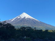
Volcan Osorno

Osorno at 4000 feet

Volcan Calbuco

Puerto Varas is a vacation community along the Llanquihue lake, with great views of the two volcanoes.  The downtown area looks like an alpine village in Germany, due to the influence of the German diaspora living in the region.  

Cataracts

Puerto Varas

Osorno and Calbuco


Chilean Patagonia


Rounding Cape Horn 


Although Francis Drake was the first to sail around Cape Horn, it was actually named by Dutch sailors Willem Schouten and Jacob Le Maire for the city of Hoorn Netherlands.  

Our ship rounded Cape Horn on Sunday Feb 11 from east to west (56 degrees South, 66 West) into the Drake Passage, then circled and passed from west to east, finally sailing into the Beagle Channel on the way to Ushuaia.  The seas were surprisingly calm given we were in one of the most hazardous waters in the world.  We had great views of Cape Horn, the small building where a lone Chilean Naval Sentry maintains watch (along with his lucky wife and children, living in the remotest place on earth) and the Lost Fisherman’s Memorial which memorializes the 10,000 sailors who have died rounding the Horn.

Cape Horn from the south

Cape Horn from the east

It's hard to see in this photo, but the Naval Sentry station is visible on the bluff in the middle of the picture, and the Lost Fisherman's memorial can be seen to the left.  Unfortunately, this is as close as we could get.  


The book Rounding the Horn by Dallas Murphy was recommended by a friend, and provided invaluable insight into the history of discovering sea lanes in Tierra del Fuego, and the story of the author’s personal voyage around the cape.  


Punta Arenas

Punta Arenas is located on the Straits of Magellan, named after Ferdinand Magellan who first “discovered” (natives already lived there) this passage to the Pacific (which he named) in 1520. 

Exploring the town on a rainy day, we saw Bories Street (main shopping street), Plaza de Armas main square, Ferdinand Magellan monument, the El Ovejero shepherd monument, and the Maggiorino Borgatello Museum.  

Magellan monument

Punta Arenas Cathedral

Sunset leaving Punta Arenas


Puerto Chacabuco, located on Aysen Fjord

Visited Rio Simpson National Reserve, Lago (lake) Ruesco, Virgin Falls, and the confluence of the Simpson and Maniguales rivers to form the Aysen river.  Despite the low clouds, we could see beautiful mountains and rock formations of the Parque Aiken del Sur, with the river valley cutting through the mountains.  

Visited small town of Puerto Aysen (ice-in), where they are very proud of the Presidente Ibanez Puente (Bridge) over the Aysen river.  They claim it is the second longest bridge in Chile, and was designed by the same architect as the Golden Gate Bridge (I could not verify that!)


Aysen

Same architect as Golden Gate Bridge?